Garmin
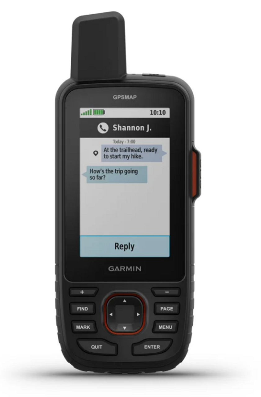
Garmin GPSMAP 67i Handheld GPS
LOGIN IN TO SEE MEMBER PRICING IF AVAILABLE.
Use the "Request Quote" button below for quotes, bulk discounts, out-of-stock, regulated products, or tax-exempt sales.
- SKU:
- Garmin-010-02812-00
- UPC:
- 753759308636
- MPN:
- 010-02812-00
- Availability:
- Shipped from our or manufacturers warehouse, You will be notified of any delays. Your card will not be charged until product ships.
- Weight:
- 0.60 LBS








Related Products


Garmin GPSMAP 86sci Marine Handheld GPS
Garmin


Garmin Montana 710i Handheld GPS
Garmin


Garmin Montana 710 Handheld GPS
Garmin


Garmin Montana® 760i Handheld GPS
Garmin


Garmin GPS MAP 66i GPS Handheld and Satellite Communicator
Garmin
Description
Garmin GPSMAP 67i Handheld GPS with inReach Satellite Communication
The Garmin GPSMAP 67i is built for hikers, hunters, backcountry users, search-and-rescue personnel, outdoor professionals, and anyone who needs reliable navigation beyond cellular coverage. It combines multi-band GNSS, preloaded routable TopoActive maps, a 3-inch sunlight-readable color display, advanced navigation sensors, long battery life, and built-in inReach satellite communication in a rugged handheld platform.
The GPSMAP 67i is particularly useful for extended trips where a smartphone may not provide sufficient battery life, mapping, or communication coverage. With an active inReach subscription, the device can send and receive messages, share location information, access supported weather services, and initiate an interactive SOS through satellite communication.
Built-In inReach Satellite Communication
The GPSMAP 67i includes inReach satellite technology for communication outside normal cellular coverage. With an active satellite subscription and adequate view of the sky, users can send and receive two-way text messages, exchange locations, share trip progress, and use supported satellite weather services.
This provides a separate communication method for remote areas where cellular service is unavailable or unreliable.
An active satellite subscription is required for inReach messaging, tracking, satellite weather, and interactive SOS functionality. Satellite performance depends on an adequate view of the sky.
Interactive SOS
A dedicated interactive SOS function can be used to contact Garmin's supported emergency-response services through the inReach satellite network when an active subscription is in place.
Unlike a one-way distress beacon, the system supports two-way communication so users can provide additional information about the emergency while response assistance is being coordinated.
Multi-Band GNSS Positioning
The GPSMAP 67i supports multi-band GNSS, allowing the receiver to use multiple satellite frequencies for improved positioning performance in challenging environments.
This can be particularly useful in mountains, forests, canyons, and other locations where terrain or vegetation can obstruct or reflect satellite signals. More consistent positioning can improve recorded tracks, waypoint accuracy, distance measurements, and navigation.
Multiple Global Navigation Satellite Systems
In addition to multi-band capability, the GPSMAP 67i can access multiple global navigation satellite systems, including GPS, Galileo, QZSS, BeiDou, and IRNSS.
Using multiple satellite systems gives the receiver access to more positioning sources than relying on GPS alone, which can improve performance in difficult terrain.
Preloaded Routable TopoActive Maps
The GPSMAP 67i comes with preloaded routable TopoActive maps designed for outdoor navigation. Map information includes roads, trails, terrain features, parks, forests, wilderness areas, and searchable points of interest.
The device can calculate supported turn-by-turn routes for outdoor activities while still providing traditional handheld navigation through waypoints, courses, tracks, and routes.
Direct-to-Device Satellite Imagery
The GPSMAP 67i supports satellite imagery downloaded directly to the device. Aerial imagery can provide additional geographic context for terrain, vegetation, water features, clearings, roads, and surrounding land.
For hunters, hikers, and backcountry travelers, this can make it easier to interpret an unfamiliar area than relying on contour and trail information alone.
Detailed Hydrographic and Land Information
Preloaded mapping includes detailed geographic information such as coastlines, lake and river shorelines, wetlands, and perennial and seasonal streams.
The GPSMAP 67i also displays national, state, and local parks, forests, wilderness areas, and searchable outdoor points of interest such as campgrounds, scenic lookouts, and picnic areas.
3-Inch Sunlight-Readable Color Display
The handheld uses a 3-inch transflective color TFT display with a 240 x 400-pixel resolution. The screen is designed to remain readable outdoors without relying on a high-power smartphone-style display.
Physical buttons provide reliable operation in rain, cold weather, or when wearing gloves, making the GPSMAP 67i well suited to field conditions where touchscreen controls may be less practical.
Waypoint, Route, Course and Track Navigation
The GPSMAP 67i supports traditional handheld navigation through saved waypoints, routes, courses, and tracks. Users can mark trailheads, campsites, hunting locations, vehicles, water sources, checkpoints, or other locations they may need to return to later.
Garmin's TracBack feature can help guide the user back along a previously traveled route, providing a straightforward option when returning toward a starting location.
Large Navigation Capacity
- Waypoints / Favorites / Locations: Up to 10,000
- Routes: Up to 250
- Courses: Up to 250 with up to 200 course points each
- Track Log: Up to 20,000 points
- Saved GPX Tracks: Up to 250
- Saved FIT Activities: Up to 300
Barometric Altimeter and 3-Axis Compass
The GPSMAP 67i includes a barometric altimeter and tilt-compensated 3-axis electronic compass for additional navigation and environmental information.
The altimeter provides elevation data based on atmospheric pressure, while the electronic compass can provide directional information even when the user is standing still.
Built-In LED Beacon Flashlight
A built-in LED beacon flashlight provides an additional source of illumination in the field. It can be used for routine low-light tasks or as a visible beacon when additional signaling capability is useful.
Because the light is built into the navigation device, it provides a practical backup without requiring another piece of equipment to be carried separately.
Long Battery Life for Extended Trips
The GPSMAP 67i uses an internal rechargeable lithium-ion battery designed for extended outdoor use. Garmin rates the device for up to 165 hours with inReach enabled and 10-minute tracking and up to 180 hours in GPS mode.
For longer trips, Expedition Mode can dramatically extend runtime by reducing tracking and GPS activity.
- inReach with 10-Minute Tracking: Up to 165 hours
- GPS Mode: Up to 180 hours
- Expedition Mode with inReach: Up to 425 hours
- Expedition Mode: Up to 840 hours
Actual battery life varies according to satellite settings, inReach activity, tracking intervals, display use, wireless connectivity, temperature, and other enabled features.
MIL-STD-810 Tested Construction
The GPSMAP 67i is tested to MIL-STD-810 standards for thermal, shock, and water performance. It also carries an IPX7 water rating.
This construction is appropriate for hiking, hunting, field work, expeditions, and other outdoor environments where equipment may be exposed to impacts, rain, temperature changes, and repeated handling.
16 GB Internal Memory and microSD Expansion
The handheld includes 16 GB of internal memory, with available user space depending on installed mapping. A microSD card slot supports additional storage up to 32 GB for compatible maps and data.
This allows users to expand mapping coverage or maintain additional navigation information without replacing the device.
Garmin Explore Compatibility
The GPSMAP 67i works with the compatible Garmin Explore ecosystem for planning and managing waypoints, routes, tracks, and collections.
Trips can be prepared on a compatible device and synchronized with the handheld, reducing the need to create every route or waypoint directly through the GPSMAP's physical controls.
Garmin Messenger Compatibility
The GPSMAP 67i is compatible with the Garmin Messenger app for supported messaging functionality. The system can intelligently use available Wi-Fi, cellular, or satellite connectivity depending on what is accessible.
This helps maintain a consistent messaging experience while conserving satellite usage when conventional connectivity is available.
Smart Notifications and Wireless Connectivity
When paired with a compatible smartphone, the GPSMAP 67i can display supported smart notifications directly on the handheld.
Wireless connectivity includes Wi-Fi, Bluetooth, and ANT+, allowing the device to communicate with compatible Garmin products, smartphones, sensors, and applications.
Key Features
- Rugged handheld GPS and satellite communicator
- Built-in inReach satellite technology
- Two-way satellite text messaging with active subscription
- Interactive SOS with active subscription
- Location sharing and tracking
- Supported satellite weather services
- Multi-band GNSS positioning
- Multiple global satellite-system support
- Preloaded routable TopoActive maps
- Direct-to-device satellite imagery
- Detailed hydrographic map features
- National, state, and local park and wilderness information
- Searchable outdoor points of interest
- 3-inch sunlight-readable color display
- Physical button controls
- Point-to-point navigation
- TracBack navigation
- Up to 10,000 waypoints
- Up to 250 routes
- Up to 250 courses
- 20,000-point track log
- Barometric altimeter
- Tilt-compensated 3-axis electronic compass
- Built-in LED beacon flashlight
- Garmin Explore compatibility
- Garmin Messenger app compatibility
- Smart notifications with compatible smartphone
- Wi-Fi connectivity
- Bluetooth connectivity
- ANT+ connectivity
- 16 GB internal memory
- microSD expansion up to 32 GB
- USB-C interface
- MIL-STD-810 tested for thermal, shock, and water performance
- IPX7 water rating
- Rechargeable internal lithium-ion battery
- Up to 180 hours in GPS mode
- Up to 840 hours in Expedition Mode
Specifications
- Manufacturer: Garmin
- Model: GPSMAP 67i
- Manufacturer Part Number: 010-02812-00
- UPC: 753759308636
- Product Type: Handheld GPS / Satellite Communicator
- Dimensions: 2.5" x 6.4" x 1.4" (6.2 x 16.3 x 3.5 cm)
- Weight: 8.1 oz (230 g)
- Lens Material: Chemically Strengthened Glass
- Display Type: Transflective Color TFT
- Display Size: 3" Diagonal
- Display Dimensions: 1.5" x 2.5" (3.8 x 6.3 cm)
- Display Resolution: 240 x 400 Pixels
- Preloaded Maps: Routable TopoActive Maps
- Internal Memory: 16 GB
- External Memory: microSD Card Support up to 32 GB
- Multi-Band GNSS: Yes
- Satellite Systems: GPS, Galileo, QZSS, BeiDou, IRNSS
- Compass: Tilt-Compensated 3-Axis Electronic Compass
- Altimeter: Barometric
- Wireless Connectivity: Wi-Fi, Bluetooth, ANT+
- Interface: USB-C
- inReach Satellite Communication: Yes
- Water Rating: IPX7
- Environmental Testing: MIL-STD-810 for Thermal, Shock and Water
- Battery Type: Internal Rechargeable Lithium-Ion
- Battery Life with inReach 10-Minute Tracking: Up to 165 Hours
- Battery Life in GPS Mode: Up to 180 Hours
- Expedition Mode with inReach: Up to 425 Hours
- Expedition Mode: Up to 840 Hours
Important inReach Information
The GPSMAP 67i can perform standard GPS navigation without an active inReach subscription. However, inReach satellite messaging, tracking, supported satellite weather services, and interactive SOS functionality require an active satellite subscription.
Some jurisdictions regulate or prohibit the use of satellite communication devices. Users are responsible for understanding and following applicable laws in the areas where the GPSMAP 67i will be used.
WARNING This product may contain chemicals known to the State of California to cause cancer and birth defects or other reproductive harm. For more information, visit www.P65Warnings.ca.gov. You must be 18 or older to shop or purchase on our website, and 21 or older to purchase ammunition or firearms. Check local laws before ordering. By ordering, you certify that you meet all federal, state, and local legal requirements. There are no returns or exchanges on armor, firearms, ammunition, or PPE. Ammunition ships UPS Ground to the lower 48 states.
We reserve the right to correct critical errors.