Garmin
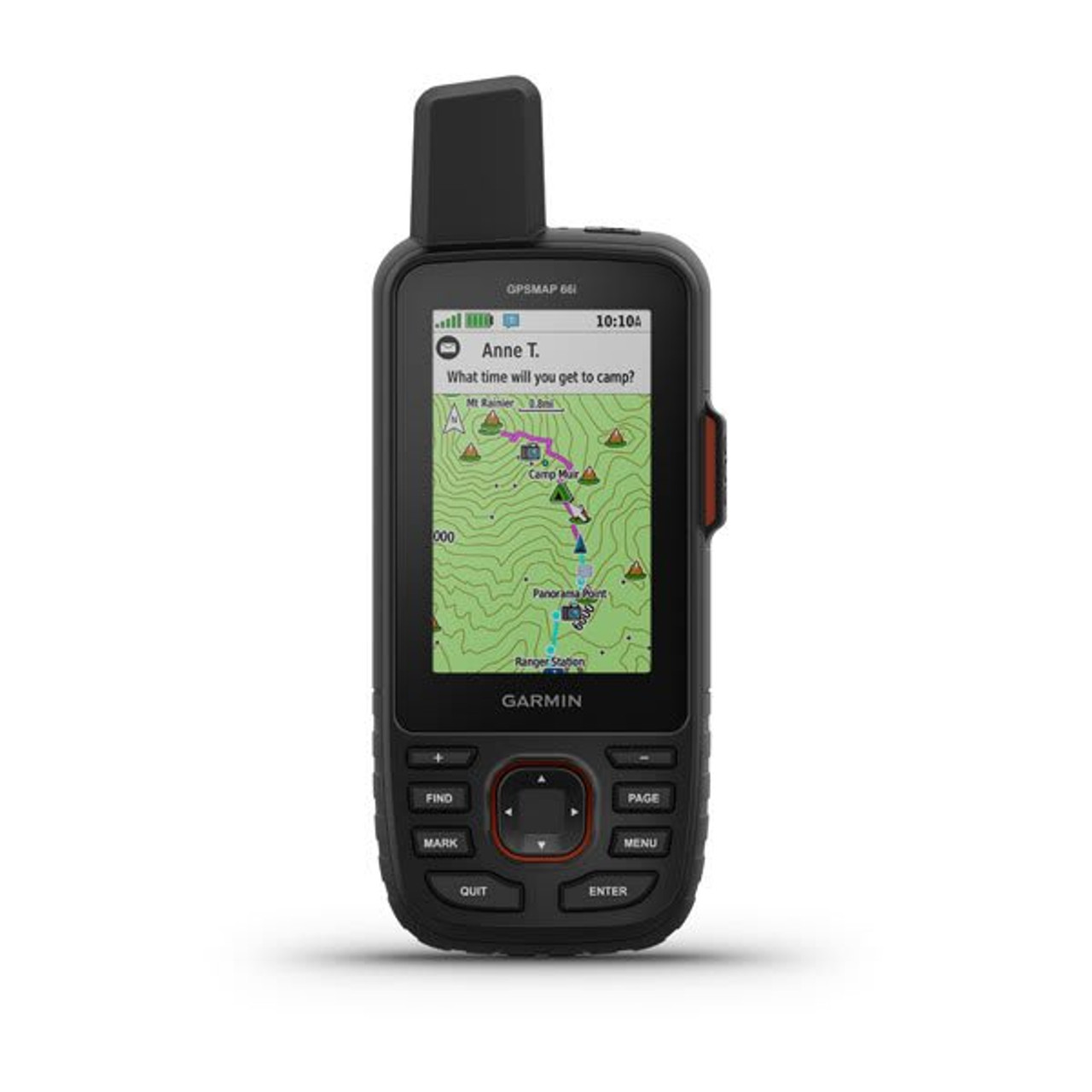
Garmin GPS MAP 66i GPS Handheld and Satellite Communicator
LOGIN IN TO SEE MEMBER PRICING IF AVAILABLE.
Use the "Request Quote" button below for quotes, bulk discounts, out-of-stock, regulated products, or tax-exempt sales.
- SKU:
- Garmin-010-02088-01
- UPC:
- 753759218737
- MPN:
- 010-02088-01
- Availability:
- Shipped from our or manufacturers warehouse.
- Weight:
- 0.60 LBS







Related Products


Garmin GPSMAP 67i Handheld GPS
Garmin


Garmin Montana 710i Handheld GPS
Garmin


Garmin Montana 710 Handheld GPS
Garmin


Garmin Montana® 760i Handheld GPS
Garmin


Garmin GPSMAP 86sci Marine Handheld GPS
Garmin
Description
Garmin GPSMAP 66i GPS Handheld and Satellite Communicator
The Garmin GPSMAP 66i is designed for hikers, hunters, backcountry travelers, outdoor professionals, and anyone who needs dependable navigation and communication beyond cellular coverage. It combines a rugged button-operated GPS handheld with preloaded TopoActive mapping, multi-GNSS positioning, ABC navigation sensors, BirdsEye Satellite Imagery, and built-in inReach satellite communication.
The practical advantage of the GPSMAP 66i is having navigation and communication in one dedicated field device. Users can follow routes, save waypoints, review terrain, and navigate with onboard maps while also maintaining access to two-way satellite messaging, location sharing, weather information, and interactive SOS functionality with an active inReach subscription.
Built-In inReach Satellite Communication
The GPSMAP 66i incorporates inReach technology for communication beyond normal cellular networks. With an active satellite subscription, users can send and receive two-way text messages, share their location, track trip progress, and communicate with other compatible inReach users.
Satellite communication is handled through the global Iridium satellite network rather than relying on nearby cellular towers, making the device particularly useful in remote areas where conventional phone service may be unavailable.
An active satellite subscription is required for inReach messaging, tracking, weather, and SOS functions.
Interactive SOS
In an emergency, the GPSMAP 66i can send an interactive SOS alert through the inReach satellite network to Garmin's supported emergency response coordination service.
Unlike a simple one-way distress transmission, interactive SOS supports two-way communication so additional information about the emergency can be exchanged while assistance is being coordinated.
Location Tracking and Sharing
With an active inReach subscription, users can track their location and share trip progress with family, friends, or other contacts. Recipients can follow the user's movement and, where supported, request the device's current GPS position.
This makes the GPSMAP 66i useful for extended backcountry trips where people at home may want confirmation of progress even when the traveler is outside cellular coverage.
Multi-GNSS Navigation
The GPSMAP 66i supports GPS and Galileo satellite systems. Access to multiple global navigation satellite systems can improve positioning performance in challenging environments compared with relying on GPS alone.
This can be particularly useful in forests, mountains, valleys, and other areas where terrain or vegetation partially obstructs the sky.
Preloaded TopoActive U.S. and Canada Maps
The handheld comes with preloaded TopoActive maps of the United States and Canada. These maps provide detailed geographic information including terrain contours, elevation data, summits, parks, coastlines, rivers, lakes, and other geographic features.
Having maps stored directly on the device allows users to navigate without depending on cellular data or downloading map information while already in the field.
BirdsEye Satellite Imagery
The GPSMAP 66i includes access to BirdsEye Satellite Imagery, allowing high-resolution satellite imagery to be downloaded directly to the device without an annual imagery subscription.
Photo-realistic aerial views can help users identify trails, parking areas, clearings, terrain features, hunting locations, and other points that may be easier to interpret from imagery than from a conventional topographic map alone.
ABC Navigation Sensors
The GPSMAP 66i includes ABC sensors for additional navigation and environmental information beyond satellite positioning.
- Altimeter: Provides elevation information while traveling through changing terrain.
- Barometer: Monitors atmospheric pressure and can provide additional context about changing weather conditions.
- 3-Axis Electronic Compass: Provides heading information even when the user is standing still.
3-Inch Sunlight-Readable Color Display
The handheld uses a 3-inch transflective color TFT display with a 240 x 400-pixel resolution. The screen is designed for outdoor readability while keeping power consumption lower than a conventional smartphone-style display.
Physical button controls allow the device to be operated in rain, cold weather, or while wearing gloves without depending on a touchscreen.
Built for Demanding Field Conditions
The GPSMAP 66i is built to MIL-STD-810 standards for thermal, shock, and water performance. It also carries an IPX7 water rating, making it appropriate for use in demanding outdoor environments.
The rugged construction is intended for hiking, hunting, field work, expeditions, and other activities where equipment may be exposed to impacts, changing temperatures, rain, and repeated handling.
Night Vision Goggle Compatibility
The GPSMAP 66i is compatible with night vision goggles, making it better suited to low-light field use than a conventional consumer GPS device.
This can be useful for trained personnel and outdoor users who operate after dark and need to reference navigation information without relying on a bright conventional display.
Built-In LED Flashlight
A built-in LED flashlight provides an additional source of illumination without requiring another handheld device. The light can also be used as a beacon for signaling.
For users already carrying the GPSMAP 66i as a primary navigation device, the integrated light provides a practical backup for low-light tasks or emergency visibility.
Optional inReach Weather
With an active inReach subscription, users can request supported weather forecasts for their current position, selected waypoints, or destinations along a route.
This can provide useful planning information when traveling through remote areas where cellular weather services may not be available.
Active Weather with Compatible Smartphone
When paired with a compatible smartphone, the GPSMAP 66i can access real-time forecast information and live weather radar.
This gives users additional weather awareness when cellular or data connectivity is available while still retaining satellite-based weather options for more remote conditions.
Garmin Explore Compatibility
The GPSMAP 66i works with the Garmin Explore ecosystem for trip planning and navigation management. Users can plan, review, and synchronize waypoints, routes, and tracks using the compatible Garmin Explore mobile app and web-based tools.
Completed activities can also be reviewed while still in the field, helping users maintain organized trip data without creating every route directly on the handheld.
Wikiloc Trail Support
The GPSMAP 66i includes support for Wikiloc trails, allowing users to download hiking, cycling, and other routes shared by outdoor users.
This can expand the device's usefulness for discovering existing routes and exploring areas where community-generated trail information is available.
Battery Life for Extended Trips
The GPSMAP 66i uses an internal rechargeable lithium-ion battery. Garmin rates the device for up to 35 hours with 10-minute tracking and up to 200 hours in Expedition Mode with 30-minute tracking.
Expedition Mode reduces tracking frequency and power consumption, allowing the handheld to remain operational for much longer periods during extended trips.
- Default Tracking Mode: Up to 35 hours with 10-minute tracking
- Expedition Mode: Up to 200 hours with 30-minute tracking
Actual battery life varies according to satellite use, tracking interval, display use, wireless connectivity, environmental conditions, and other enabled features.
Key Features
- Rugged handheld GPS and satellite communicator
- Built-in inReach satellite technology
- Two-way satellite messaging with active subscription
- Interactive SOS with active subscription
- Location tracking and sharing with active subscription
- Global Iridium satellite network communication
- GPS and Galileo satellite support
- Preloaded TopoActive U.S. and Canada maps
- Terrain contours and topographic elevation data
- BirdsEye Satellite Imagery
- No annual subscription required for BirdsEye imagery
- Wikiloc trail support
- 3-inch sunlight-readable color display
- Physical button controls
- Barometric altimeter
- 3-axis electronic compass
- Built-in LED flashlight
- Beacon capability
- Optional inReach weather
- Active weather with compatible smartphone
- Garmin Explore compatibility
- Night vision goggle compatible
- MIL-STD-810 tested for thermal, shock, and water performance
- IPX7 water rating
- 16 GB internal memory
- Rechargeable internal lithium-ion battery
- Up to 35 hours in 10-minute tracking mode
- Up to 200 hours in Expedition Mode
Specifications
- Manufacturer: Garmin
- Model: GPSMAP 66i
- Manufacturer Part Number: 010-02088-01
- UPC: 753759218737
- Product Type: Handheld GPS / Satellite Communicator
- Dimensions: 2.5" x 6.4" x 1.4" (6.2 x 16.3 x 3.5 cm)
- Weight: 8.1 oz (230 g)
- Display Type: Transflective Color TFT
- Display Size: 3" Diagonal
- Display Dimensions: 1.5" W x 2.5" H (3.8 x 6.3 cm)
- Display Resolution: 240 x 400 Pixels
- Preloaded Maps: TopoActive U.S. and Canada
- Memory / History: 16 GB
- Satellite Systems: GPS and Galileo
- Compass: 3-Axis Electronic Compass
- Altimeter: Barometric
- inReach Satellite Communication: Yes
- Water Rating: IPX7
- Environmental Testing: MIL-STD-810 for Thermal, Shock and Water
- Interface: High-Speed Micro USB / NMEA 0183 Compatible
- Battery Type: Rechargeable Internal Lithium-Ion
- Battery Life: Up to 35 Hours with 10-Minute Tracking
- Expedition Battery Life: Up to 200 Hours with 30-Minute Tracking
What's Included
- Garmin GPSMAP 66i
- Access to BirdsEye Satellite Imagery
- USB cable
- Carabiner clip
- Documentation
Important inReach Information
The GPSMAP 66i can perform standard GPS navigation without an active inReach subscription. However, two-way satellite messaging, location tracking and sharing, interactive SOS, and supported inReach weather services require an active satellite subscription.
WARNING This product may contain chemicals known to the State of California to cause cancer and birth defects or other reproductive harm. For more information, visit www.P65Warnings.ca.gov. You must be 18 or older to shop or purchase on our website, and 21 or older to purchase ammunition or firearms. Check local laws before ordering. By ordering, you certify that you meet all federal, state, and local legal requirements. There are no returns or exchanges on armor, firearms, ammunition, or PPE. Ammunition ships UPS Ground to the lower 48 states.
We reserve the right to correct critical errors.