Garmin
Garmin Tread XL - Overland Edition 10” All-Terrain Navigator
LOGIN IN TO SEE MEMBER PRICING IF AVAILABLE.
Use the "Request Quote" button below for quotes, bulk discounts, out-of-stock, regulated products, or tax-exempt sales.
- SKU:
- Garmin-10-02509-00
- UPC:
- 753759277598
- MPN:
- 10-02509-00
- Availability:
- Shipped from our or manufacturers warehouse.
- Weight:
- 0.60 LBS




Related Products

Garmin Tread Overland Edition 8” All-Terrain Navigator
Garmin

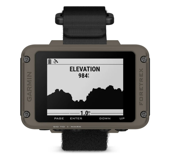
Garmin Foretrex 901 Ballistic Edition Wrist-mounted GPS Navigator with Strap
Garmin


Garmin Epix Sapphire Edition 47mm Smartwatch
Garmin

Garmin Tactix 7 AMOLED Edition Smartwatch
Garmin
Description
Garmin Tread XL Overland Edition 10" All-Terrain GPS Navigator with inReach
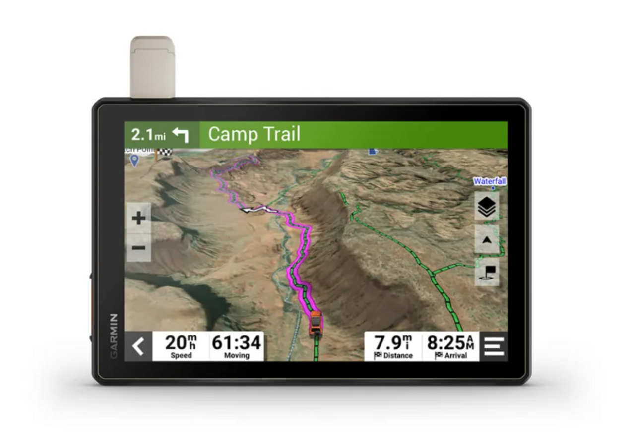
The Garmin Tread XL Overland Edition is built for overlanders, off-road travelers, expedition vehicles, RV users, and backcountry explorers who need more than conventional street navigation. Its large 10-inch ultrabright touchscreen combines turn-by-turn trail guidance, topographic mapping, vehicle-aware routing, public and private land information, satellite imagery, camping points of interest, and built-in inReach satellite communication in a rugged vehicle-mounted navigator.
The practical advantage of the Tread XL is having navigation information designed specifically for travel beyond paved roads. Instead of relying entirely on cellular coverage or a phone-sized display, users can plan and follow routes using dedicated off-road mapping while maintaining access to compatible weather, tracking, communication, and vehicle-control features throughout the trip.
Large 10-Inch Ultrabright Touchscreen
The Tread XL uses an ultrabright 10-inch touchscreen designed for visibility inside an adventure vehicle in bright daylight as well as after dark. The large display provides considerably more room for maps, terrain details, route information, and vehicle data than a handheld GPS or smartphone.
The screen is glove-friendly and can be mounted in either portrait or landscape orientation, allowing the installation to be configured around the driver's preferred layout and available dashboard space.
Turn-by-Turn Navigation for Unpaved Roads and Trails
The Tread XL is built around off-road navigation rather than simply adapting a street navigator for dirt roads. It provides turn-by-turn trail navigation using map content derived from OpenStreetMap and U.S. Forest Service Motor Vehicle Use Maps.
For overlanders and off-road travelers, this provides access to adventure roads and trails that may not be emphasized on conventional automotive navigation systems.
Map data may not reflect every closure, restriction, trail condition, or local rule. Posted signs, land-use regulations, and actual road and trail conditions should always take priority over navigation suggestions.
Topographic Maps with 3D Terrain
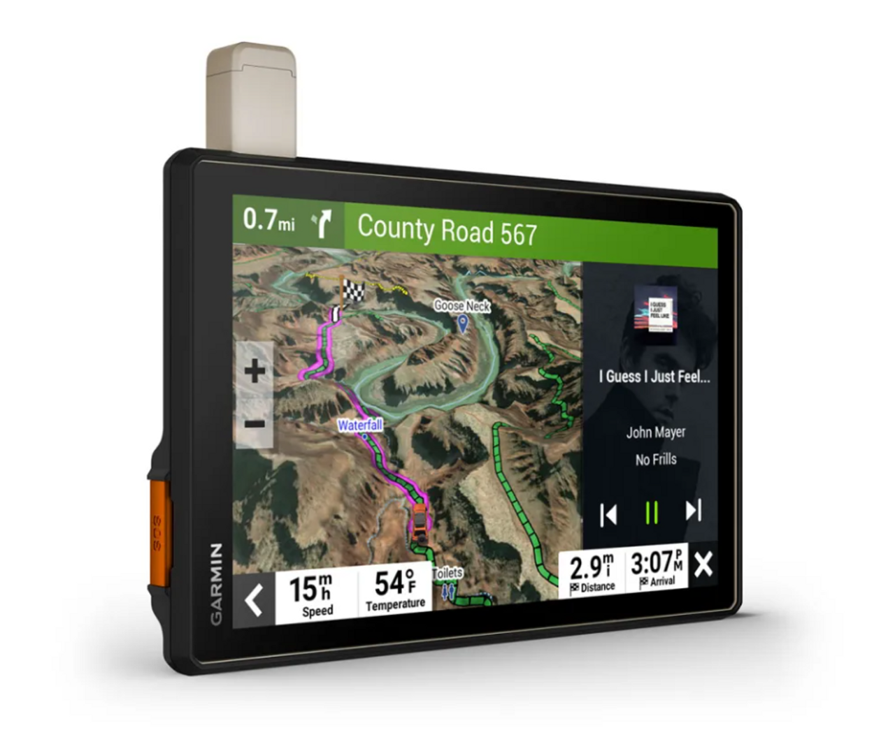
Preloaded topographic maps with 3D terrain cover North and South America, providing useful geographic context when traveling through mountains, desert terrain, forests, and remote areas.
Viewing elevation and surrounding terrain on the large display can help users better understand the route ahead rather than navigating from a simple road line alone.
Custom Routing for Your Vehicle
On supported roads, the Tread XL can calculate routes using the entered size and weight characteristics of the vehicle. This is particularly useful for larger overland rigs, trucks, vans, and recreational vehicles where width, height, length, or weight can affect route suitability.
Vehicle-aware routing should be treated as an additional planning tool rather than a guarantee of clearance. Drivers remain responsible for checking signs, bridge limits, road conditions, trail restrictions, and actual vehicle clearance before proceeding.
Built-In inReach Satellite Communication
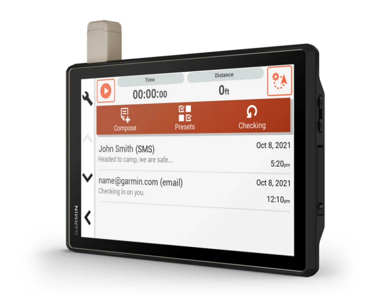
The Tread XL Overland Edition incorporates inReach satellite communication technology for users traveling beyond normal cellular coverage. With an active satellite subscription and adequate view of the sky, supported features include two-way text messaging, location sharing, and interactive SOS communication.
For remote overland travel, inReach provides a separate communication path that does not depend on a nearby cell tower. This can be particularly valuable during multi-day trips through backcountry areas where cellular coverage is inconsistent or unavailable.
An active satellite subscription is required for inReach communication features. Satellite-device use may be regulated or prohibited in some jurisdictions, and users are responsible for understanding applicable laws where the device will be operated.
Interactive SOS
With an active inReach subscription, the Tread XL can initiate an interactive SOS through Garmin's supported emergency-response services. Unlike a one-way distress transmission, interactive communication allows information about the emergency to be exchanged while assistance is being coordinated.
The feature should be treated as one part of an overall emergency plan and does not replace appropriate recovery equipment, vehicle preparation, first-aid supplies, or other safety measures required for remote travel.
Public and Private Land Boundaries
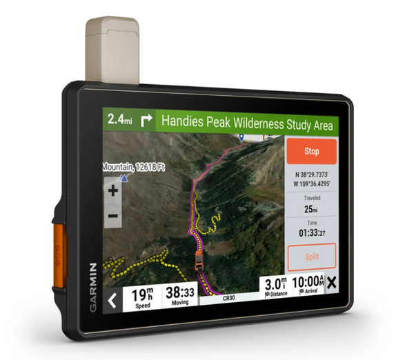
For users traveling through the United States, the Tread XL can display public land boundaries including national forests, Bureau of Land Management areas, wilderness areas, and other covered public lands.
Private land boundaries and available landowner information for parcels greater than 4 acres provide additional context when selecting campsites, routes, staging locations, or access points.
This information is useful for trip planning but should not be considered a substitute for posted property markers, official land-management rules, or current access restrictions.
BirdsEye Direct Satellite Imagery
BirdsEye Direct Satellite Imagery provides high-resolution aerial views of terrain that can be downloaded directly to the navigator over Wi-Fi without an annual imagery subscription.
Satellite imagery can provide additional context around terrain, road networks, clearings, water features, and surrounding geography that may not be obvious from conventional map layers alone.
Trail Difficulty Ratings
Garmin's growing trail database includes difficulty ratings for supported off-road riding areas across the United States where information is available.
These ratings can help users evaluate potential routes during trip planning, but actual trail difficulty can change significantly due to weather, erosion, snow, vehicle traffic, maintenance, and other conditions.
Preloaded Camping Points of Interest
The Tread XL includes preloaded iOverlander points of interest and Ultimate Public Campgrounds information, helping travelers locate established, wild, and dispersed camping options without depending entirely on a live cellular connection.
For long-distance overland trips, having campground and travel points stored directly on the navigator can simplify route planning when traveling through areas with limited data coverage.
Altimeter, Barometer and Compass
Built-in ABC sensors provide additional environmental and navigation information beyond GPS positioning.
- Altimeter: Provides elevation information while traveling through changing terrain.
- Barometer: Monitors atmospheric pressure for additional environmental awareness.
- Compass: Provides directional reference independent of road navigation.
- Pitch and Roll Gauges: Display vehicle angle information when traveling across uneven terrain.
Pitch and Roll Gauges
Integrated pitch and roll gauges provide a visual indication of the vehicle's angle while operating on uneven terrain.
This information gives drivers additional awareness of vehicle attitude on climbs, descents, and side slopes. It should be treated as supplemental information rather than a determination that a particular obstacle or angle is safe for a specific vehicle.
IP67 Weather-Resistant Construction
The Tread XL is purpose-built for all-terrain vehicle use and carries an IP67 rating for protection against dust and temporary water immersion under specified test conditions.
This rugged construction makes it better suited to open vehicles, dusty trails, changing weather, and expedition environments than consumer navigation devices designed primarily for enclosed passenger vehicles.
Locking Magnet-Assisted Mount
An included locking magnet-assisted mount secures the navigator inside the vehicle while allowing convenient installation and removal.
The mounting system is particularly important for a large 10-inch navigator used over rough terrain, where vibration and repeated impacts place greater demands on the connection between the device and vehicle.
Tread App Route Planning
The compatible Tread app allows users to plan routes using the same general vehicle profiles, map information, and route preferences available on the navigator.
Routes can be prepared on a compatible smartphone before departure and then synchronized with the Tread device, reducing the need to perform all trip planning directly on the vehicle-mounted screen.
Sync Waypoints, Tracks and Routes
The Tread ecosystem can synchronize waypoints, tracks, routes, and collections across compatible devices. GPX files can also be imported and shared for trip planning and route exchange.
This makes the system particularly useful for overlanding groups or users who maintain an organized library of routes, campsites, trailheads, and destinations across multiple trips.
Group Ride Mobile
Group Ride Mobile allows compatible users running the Tread app to view participating friends from a smartphone or compatible Tread navigator.
This can provide useful location awareness when multiple vehicles are traveling together, although functionality depends on compatible devices, application configuration, and available connectivity.
Live Weather and Radar
When paired with a compatible smartphone and the Tread app, the navigator can display live weather information, storm alerts, and animated radar.
For travelers moving through remote or rapidly changing environments, weather information can provide valuable context before committing to exposed routes, mountain passes, desert trails, or extended off-pavement sections.
Garmin PowerSwitch Compatibility
The Tread XL can pair with a compatible Garmin PowerSwitch digital switch box to provide on-screen control of supported 12-volt vehicle accessories.
Depending on the vehicle installation, this can provide centralized touchscreen control of equipment such as auxiliary lighting and other compatible electrical accessories without adding a separate physical switch panel for every circuit.
Garmin PowerSwitch is sold separately.
Group Ride Radio Compatibility
The navigator can be paired with a compatible Garmin Group Ride Radio for supported communication and tracking between Tread-equipped vehicles.
This can be useful for convoys and group trail travel where maintaining awareness of other vehicles is important.
Compatible Group Ride Radio equipment is sold separately.
Garmin Dog Tracking Compatibility
The Tread XL can wirelessly pair with select compatible Garmin GPS dog-tracking systems. When configured, dog locations can appear as markers directly on the navigator's map screen.
This allows hunters and sporting-dog handlers to view vehicle navigation and compatible dog location information on the same large display.
Compatible Garmin dog-tracking equipment is sold separately.
External GPS and inReach Antenna Support
Users who require improved antenna placement can add compatible external GPS and inReach antennas. These accessories use low-profile, water-resistant housings and provide additional mounting flexibility for larger vehicles or installations where the navigator does not have an ideal view of the sky.
External antennas are sold separately.
Key Features
- 10-inch all-terrain GPS navigator for overlanding and off-road travel
- Ultrabright glove-friendly touchscreen
- Portrait or landscape mounting
- Turn-by-turn trail navigation
- OpenStreetMap road and trail data
- U.S. Forest Service Motor Vehicle Use Map content
- Preloaded topographic maps
- 3D terrain display
- North and South America topographic coverage
- Detailed North American street maps
- Vehicle size and weight routing on supported roads
- Built-in inReach satellite communication
- Two-way satellite messaging with active subscription
- Location sharing with active subscription
- Interactive SOS with active subscription
- U.S. public land boundaries
- Private land boundary information
- BirdsEye Direct Satellite Imagery
- No annual subscription required for BirdsEye Direct imagery
- Available off-road trail difficulty ratings
- Preloaded iOverlander points of interest
- Preloaded Ultimate Public Campgrounds information
- Built-in altimeter
- Built-in barometer
- Built-in compass
- Pitch and roll gauges
- IP67 weather-resistant construction
- Locking magnet-assisted vehicle mount
- Tread app compatibility
- Route planning from compatible smartphone
- Waypoint, track, route, and collection synchronization
- GPX file import and sharing
- Group Ride Mobile support
- Live weather and storm alerts with compatible smartphone
- Animated weather radar with compatible smartphone
- Garmin PowerSwitch compatibility
- Compatible Group Ride Radio support
- Compatible Garmin GPS dog-tracking support
- External GPS antenna support
- External inReach antenna support
- Wi-Fi connectivity
- Bluetooth connectivity
Specifications
- Manufacturer: Garmin
- Model: Tread XL - Overland Edition
- Manufacturer Part Number: 010-02509-00
- UPC: 753759277598
- Product Type: All-Terrain / Overland GPS Navigator
- Display Size: 10"
- Display: Ultrabright Color Touchscreen
- Touchscreen: Yes
- Glove-Friendly: Yes
- Display Orientation: Portrait or Landscape
- Satellite Communication: Built-In inReach
- Satellite Messaging: Yes, Active Subscription Required
- Interactive SOS: Yes, Active Subscription Required
- Topographic Maps: Preloaded
- 3D Terrain: Yes
- Street Navigation: Yes
- Vehicle Profile Routing: Yes, Where Supported
- Satellite Imagery: BirdsEye Direct
- Wi-Fi: Yes
- Bluetooth: Yes
- Altimeter: Yes
- Barometer: Yes
- Compass: Yes
- Pitch / Roll Gauges: Yes
- Water / Dust Rating: IP67
- Mount: Locking Magnet-Assisted Mount
- Tread App Compatible: Yes
- Garmin PowerSwitch Compatible: Yes
- Compatible Dog Tracking Support: Yes
Important inReach and Navigation Information
An active satellite subscription is required for inReach satellite messaging, location sharing, and interactive SOS functionality. Some jurisdictions regulate or prohibit satellite communication devices, and users are responsible for understanding the laws applicable to the areas where the device will be used.
Off-road, street, and vehicle-profile routing should always be treated as supplementary navigation information. Map databases cannot account for every closure, obstacle, bridge restriction, trail condition, weather event, or change in land access. Always follow posted signs, current regulations, and actual road and trail conditions.
WARNING This product may contain chemicals known to the State of California to cause cancer and birth defects or other reproductive harm. For more information, visit www.P65Warnings.ca.gov. You must be 18 or older to shop or purchase on our website, and 21 or older to purchase ammunition or firearms. Check local laws before ordering. By ordering, you certify that you meet all federal, state, and local legal requirements. There are no returns or exchanges on armor, firearms, ammunition, or PPE. Ammunition ships UPS Ground to the lower 48 states.
We reserve the right to correct critical errors.